UC8 LANDSCAPE
IoT & EO services in support to European landscape adaptation to climate change
Partners: UFZ (Lead), INRAE
1.1.1 Bioindicators for value and status of landscapes with regard to pollinators
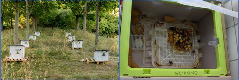
Develop, test, improve and optimise prototypes of commercially available bumble bee colonies as bioindicators for value and status of landscapes with regard to pollinators. Bumble bee colonies will be equipped with high-end sensors to assess and monitor pollinator activity, performance, and status. Application of IoT techniques to combine information from different sensors within pollinator colonies and across the agricultural landscape and develop workflows to synthesise real-time information on pollinator status across scales and related to different environmental drivers.
Expected results
- Setup of bumble bee colonies as bioindicators for landscape assessment.
- Methods for combination of multiple sensor information.
- Framework for automated pollinator monitoring Expected services.
1.1.2 Assessment and monitoring of landscape dynamics
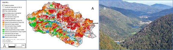
The Doller valley –France is a community of municipalities stretching from Burnhaupt-le-Bas to the Ballon d'Alsace (total area 100 km2). It has been identified by the Grand-Est region as an experimental area for fir dieback. The UC aims at combining IoT based and light phenotyping tools, up- and -down scaling proxy and remote sensing tools, data assimilation into process-based models, joint use of phenomenological and process-based models into simulation platforms to (i) cope with environmental crisis management, and (ii) feed multi-criteria and multi-risk management decision tools. Specifically, our objectives in PHENET Project are (i) testing, improving and optimising prototypes of sentinel IoTs combined with light phenotyping tools and proxy- and remote-sensing products to assess and monitor forest dynamics and health, (ii) implementing the improved techniques within tree stands and across the forest landscapes, (iii) developing the workflow between them and edge-computing to combine information from different scales (points, transects, surfaces) and real-time information on forest performance with different environmental drivers.
The expected services
- Forest growth and dieback forecasting.
- Modelling platform to be used by stakeholders (private and public forest managers).
